Pest Management Office

Rutgers, The State University of New Jersey
Search Rutgers
  • Home
  • News/Blog
  • Pesticide Safety Education Program (PSEP)
  • Pesticide Applicator Training (PAT)
    • Licensing
    • New Applicator Training
    • Manuals
    • Certification Exams
    • Recertification Courses
    • Records & Forms
    • Fact Sheets
    • Pesticide Links
  • Worker Protection
    • EPA-Approved Training Resources
    • WPS Training Recordkeeping
    • Rutgers WPS Outreach
    • Worker Protection Contacts
  • School IPM
    • NJ School Act/Reg
    • Model IPM Policy/Plan
    • Training
    • Resources
    • Tools
    • Report Cards
    • School IPM Contacts
  • Integrated Pest Management (IPM)
    • Contacts
    • Greenhouse IPM
    • Fruit IPM
    • Nursery IPM
    • Vegetable IPM
      • Personnel
      • IPM Maps
      • Scouting Forms
      • Presentations
      • Crop Certification Guidelines
      • Photo Gallery
      • Links
  • NJinPAS Project (archived)
  • Site Map
  • Contact Information
« Back to: / Integrated Pest Management (IPM) / Fruit Integrated Pest Management Program (IPM) / Fruit Integrated Pest Management Program Reports Available to Participating Growers

Fruit Integrated Pest Management Program Reports Available to Participating Growers

Geo-referenced Farm Maps

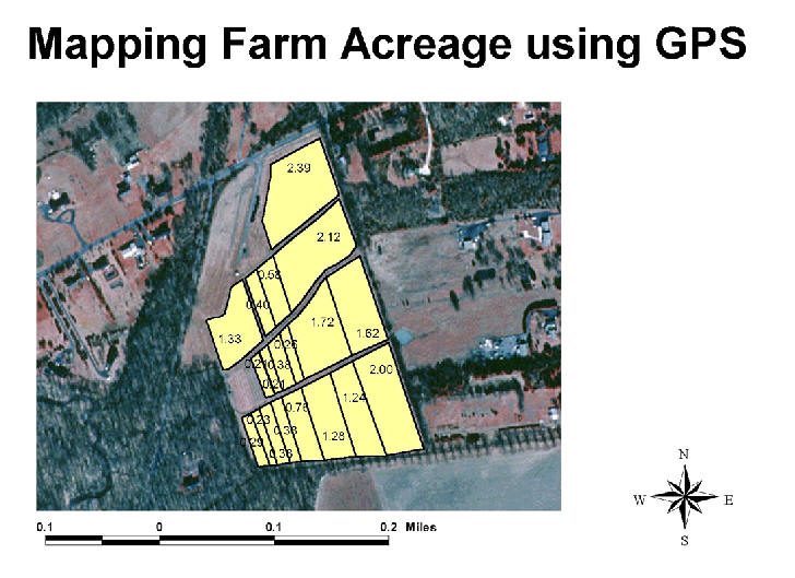
Farm maps that are created by using GIS/GPS technology have a number of uses and advantages over old hand drawn maps. A simple base map is useful for record keeping and precise acreage under production. Exact acreage may be important for production records, insurance purposes, sprayer calibration, or pesticide use records. An example of a geo-referenced farm map with exact acreage can be seen in the accompanying example.

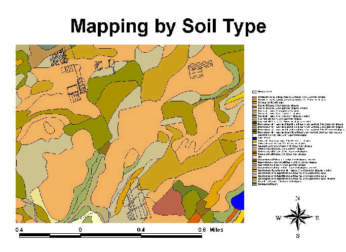
Geo-referenced maps can be overlaid with different layers of specific data. These data layers may already exist from other sources, or may be generated for a specific site. An example of a map overlay generated from existing data can be seen in a sample map by soil type. One farm may have several different soil types. Knowing the specific soil type may be useful in calculating herbicide rates or helpful in irrigation scheduling.

Specific data generated for an individual farm may include a crop variety map overlay as in the accompanying example for a peach farm . These maps may be useful for picking crews, worker protection notification, and u-pick operations.

For more information contact:

Project Coordinator:

Dean Polk, Statewide Fruit IPM Agent

Dept. of Agricultural and Resource Management Agents
Phone: 609 – 758-7311
E-mail: polk@aesop.rutgers.edu

Rutgers Fruit Research & Extension Center

283 Route 539
Cream Ridge, NJ 08514
Tel 609-758-7311
Fax 609-758-7085

Home
News/Blog
Pesticide Safety Education Program (PSEP)
Pesticide Applicator Training (PAT)
Licensing
New Applicator Training
Manuals
Certification Exams
Recertification Courses
Records & Forms
Fact Sheets
Pesticide Links
Worker Protection
EPA-Approved Training Resources
WPS Training Recordkeeping
Rutgers WPS Outreach
Worker Protection Contacts
School IPM
NJ School Act/Reg
Model IPM Policy/Plan
Training
Resources
Tools
Report Cards
School IPM Contacts
Integrated Pest Management (IPM)
Contacts
Greenhouse IPM
Fruit IPM
Nursery IPM
Vegetable IPM
Personnel
IPM Maps
Scouting Forms
Presentations
Crop Certification Guidelines
Photo Gallery
Links
NJinPAS Project (archived)
Site Map
Contact Information

Subscribe to Get News/Blog Updates via Email

Enter your email address to subscribe to this blog and receive notifications of new posts by email.

Copyright © 2023, Rutgers, The State University of New Jersey

Rutgers University is an equal access/equal opportunity institution. Individuals with disabilities are encouraged to direct suggestions, comments, or complaints concerning any accessibility issues with Rutgers web sites to: accessibility@rutgers.edu or complete the Report Accessibility Barrier or Provide Feedback Form.